Weather Alert in California
Heat Advisory issued March 10 at 12:15PM PDT until March 13 at 8:00PM PDT by NWS Los Angeles/Oxnard CA
AREAS AFFECTED: Santa Ynez Mountains Eastern Range
DESCRIPTION: * WHAT...For the Wind Advisory, north winds 15 to 25 mph with gusts up to 45 mph expected. For the Heat Advisory, temperatures near 90 expected. * WHERE...Santa Ynez Mountains Eastern Range. * WHEN...For the Wind Advisory, from 5 PM this afternoon to 9 AM PDT Wednesday. For the Heat Advisory, from 10 AM Thursday to 8 PM PDT Friday. * IMPACTS...Gusty winds will blow around unsecured objects. Tree limbs could be blown down and a few power outages may result. There is a high risk for heat illness for sensitive populations including the very young, the very old, those without air conditioning, and those active outdoors. * ADDITIONAL DETAILS...Well above normal temperatures will continue well into next week, and additional Heat Advisories or Extreme Heat Warnings may be needed.
INSTRUCTION: Winds this strong can make driving difficult, especially for high profile vehicles. Use extra caution. Drink plenty of fluids, stay in an air-conditioned room, stay out of the sun, and check up on relatives and neighbors. Take extra precautions when outside. Wear lightweight and loose fitting clothing. Try to limit strenuous activities to early morning or evening. Take action when you see symptoms of heat exhaustion and heat stroke.
Want more detail? Get the Complete 7 Day and Night Detailed Forecast!
Current U.S. National Radar--Current
The Current National Weather Radar is shown below with a UTC Time (subtract 5 hours from UTC to get Eastern Time).

National Weather Forecast--Current
The Current National Weather Forecast and National Weather Map are shown below.

National Weather Forecast for Tomorrow
Tomorrow National Weather Forecast and Tomorrow National Weather Map are show below.

North America Water Vapor (Moisture)
This map shows recent moisture content over North America. Bright and colored areas show high moisture (ie, clouds); brown indicates very little moisture present; black indicates no moisture.

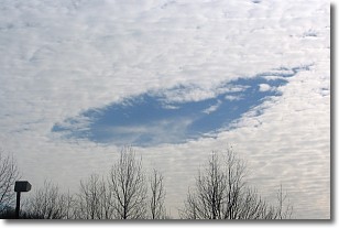
Weather Topic: What are Hole Punch Clouds?
Home - Education - Cloud Types - Hole Punch Clouds
 Next Topic: Mammatus Clouds
A hole punch cloud is an unusual occurrence when a disk-shaped
hole appears in a cirrostratus, cirrocumulus, or altocumulus cloud.
When part of the cloud forms ice crystals, water droplets in the surrounding area
of the cloud evaporate. The effect of this process produces a large elliptical
gap in the cloud. The hole punch cloud formation is rare, but it is not specific
to any geographic area.
Other names which have been used to describe this phenomena include fallstreak hole,
skypunch, and cloud hole.
Next Topic: Mammatus Clouds
Weather Topic: What are Nimbostratus Clouds?
Home - Education - Cloud Types - Nimbostratus Clouds
 Next Topic: Precipitation
A nimbostratus cloud is similar to a stratus cloud in its formless,
smooth appearance. However, a nimbostratus cloud is darker than a stratus cloud,
because it is thicker.
Unlike a stratus cloud, a nimbostratus cloud typically brings with it the threat
of moderate to heavy precipitation. In some cases, the precipitation may evaporate
before reaching the ground, a phenomenon known as virga.
Next Topic: Precipitation
Current conditions powered by WeatherAPI.com


