Weather Alert in Alaska
Winter Weather Advisory issued February 11 at 11:43AM AKST until February 12 at 3:00PM AKST by NWS Juneau AK
AREAS AFFECTED: Municipality of Skagway
DESCRIPTION: ...ACCUMULATING SNOW FOR THE NORTHERN INNER CHANNELS... .A storm force system will be moving up into the panhandle late Wednesday night, bringing the next round of more significant snow to the Haines Highway and less so for the Klondike Highway. Precipitation may begin as rain or a rain/snow mix, however, as rates increase, precipitation is expected to transition to only snow. A majority of the higher snow rates are anticipated during the early morning hours of Thursday. At this time, rates have a 30-50% chance to exceed one inch per hour during the early morning hours for Haines and Haines Highway, and around a 30% chance to exceed half an inch per hour for Skagway and the Klondike Highway. * WHAT...Snow expected. Total snow accumulations of 4 to 6 inches. * WHERE...Skagway and Klondike Highway. * WHEN...From midnight tonight to 3 PM AKST Thursday. * IMPACTS...Travel could be very difficult. * ADDITIONAL DETAILS...Heaviest snow rates are anticipated during the early morning hours of Thursday.
INSTRUCTION: Slow down and use caution while traveling. People are urged to prepare their property before the onset of winter weather. For the latest road conditions, where available, call 5 1 1 or visit 511.alaska.gov.
Want more detail? Get the Complete 7 Day and Night Detailed Forecast!
Current U.S. National Radar--Current
The Current National Weather Radar is shown below with a UTC Time (subtract 5 hours from UTC to get Eastern Time).

National Weather Forecast--Current
The Current National Weather Forecast and National Weather Map are shown below.

National Weather Forecast for Tomorrow
Tomorrow National Weather Forecast and Tomorrow National Weather Map are show below.

North America Water Vapor (Moisture)
This map shows recent moisture content over North America. Bright and colored areas show high moisture (ie, clouds); brown indicates very little moisture present; black indicates no moisture.

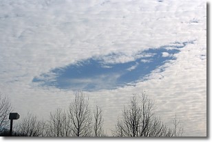
Weather Topic: What are Hole Punch Clouds?
Home - Education - Cloud Types - Hole Punch Clouds
 Next Topic: Mammatus Clouds
A hole punch cloud is an unusual occurrence when a disk-shaped
hole appears in a cirrostratus, cirrocumulus, or altocumulus cloud.
When part of the cloud forms ice crystals, water droplets in the surrounding area
of the cloud evaporate. The effect of this process produces a large elliptical
gap in the cloud. The hole punch cloud formation is rare, but it is not specific
to any geographic area.
Other names which have been used to describe this phenomena include fallstreak hole,
skypunch, and cloud hole.
Next Topic: Mammatus Clouds
Weather Topic: What are Nimbostratus Clouds?
Home - Education - Cloud Types - Nimbostratus Clouds
 Next Topic: Precipitation
A nimbostratus cloud is similar to a stratus cloud in its formless,
smooth appearance. However, a nimbostratus cloud is darker than a stratus cloud,
because it is thicker.
Unlike a stratus cloud, a nimbostratus cloud typically brings with it the threat
of moderate to heavy precipitation. In some cases, the precipitation may evaporate
before reaching the ground, a phenomenon known as virga.
Next Topic: Precipitation
Current conditions powered by WeatherAPI.com


