Weather Alert in Illinois
Flood Watch issued April 3 at 10:58AM CDT until April 5 at 1:00PM CDT by NWS Chicago IL
AREAS AFFECTED: Winnebago
DESCRIPTION: ...The Flood Watch is extended for the following rivers in Illinois... Kishwaukee River near Perryville affecting Winnebago County. For the Kishwaukee River...including Perryville...flooding is possible. * WHAT...Flooding is possible. * WHERE...Kishwaukee River from Confluence with South Branch Kishwaukee River downstream to the Rock River, including the Perryville gauge. * WHEN...From this evening to early Sunday afternoon. * IMPACTS...At 13.0 feet, Roadways threatened at Blackhawk Valley Campground south of Rockford. * ADDITIONAL DETAILS... - At 10:30 AM CDT Friday the stage was 11.1 feet. - Forecast...Flood stage may be reached late this afternoon, however there is still some uncertainty regarding the river crest. - Flood stage is 12.0 feet. - http://www.weather.gov/safety/flood
INSTRUCTION: A Flood Watch means water levels above flood stage are possible, but not yet certain, based upon the latest forecasts. Persons along rivers and streams in the watch area should monitor the latest forecasts and be prepared to take action should flooding develop. These forecasts are based on observed precipitation as well as forecast precipitation 24 hours into the future. Changes to the rainfall forecast, or any additional rainfall after 24 hours, may cause changes to these river forecasts. Additional information is available at www.weather.gov. The next statement will be issued by late tonight.
Want more detail? Get the Complete 7 Day and Night Detailed Forecast!
Current U.S. National Radar--Current
The Current National Weather Radar is shown below with a UTC Time (subtract 5 hours from UTC to get Eastern Time).

National Weather Forecast--Current
The Current National Weather Forecast and National Weather Map are shown below.

National Weather Forecast for Tomorrow
Tomorrow National Weather Forecast and Tomorrow National Weather Map are show below.

North America Water Vapor (Moisture)
This map shows recent moisture content over North America. Bright and colored areas show high moisture (ie, clouds); brown indicates very little moisture present; black indicates no moisture.

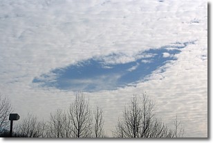
Weather Topic: What are Hole Punch Clouds?
Home - Education - Cloud Types - Hole Punch Clouds
 Next Topic: Mammatus Clouds
A hole punch cloud is an unusual occurrence when a disk-shaped
hole appears in a cirrostratus, cirrocumulus, or altocumulus cloud.
When part of the cloud forms ice crystals, water droplets in the surrounding area
of the cloud evaporate. The effect of this process produces a large elliptical
gap in the cloud. The hole punch cloud formation is rare, but it is not specific
to any geographic area.
Other names which have been used to describe this phenomena include fallstreak hole,
skypunch, and cloud hole.
Next Topic: Mammatus Clouds
Weather Topic: What are Nimbostratus Clouds?
Home - Education - Cloud Types - Nimbostratus Clouds
 Next Topic: Precipitation
A nimbostratus cloud is similar to a stratus cloud in its formless,
smooth appearance. However, a nimbostratus cloud is darker than a stratus cloud,
because it is thicker.
Unlike a stratus cloud, a nimbostratus cloud typically brings with it the threat
of moderate to heavy precipitation. In some cases, the precipitation may evaporate
before reaching the ground, a phenomenon known as virga.
Next Topic: Precipitation
Current conditions powered by WeatherAPI.com


