Weather Alert in Indiana
Flood Warning issued March 9 at 10:02PM EDT until March 16 at 10:00PM EDT by NWS Indianapolis IN
AREAS AFFECTED: Daviess, IN; Greene, IN; Knox, IN
DESCRIPTION: ...The Flood Warning continues for the following rivers in Indiana... Illinois... White River at Edwardsport. White River at Newberry. White River at Elliston. White River at Hazleton. White River at Petersburg. Wabash River at Mount Carmel. .Minor to moderate flooding continue on the White River and minor flooding continues on the lower Wabash at Mount Carmel due to heavy rainfall last week. Additional rainfall of one to two inches Tuesday through Wednesday is expected to bring additional rises on the White and lengthen the amount of time in flood for the lower White. Additional flooding is possible on the lower Wabash as well, depending on the exact location of the rainfall. The crest on the White is near Edwardsport Monday morning and expected to reach Hazleton sometime Friday. * WHAT...Minor flooding is occurring and minor flooding is forecast. * WHERE...White River at Elliston. * WHEN...Until Monday, March 16. * IMPACTS...At 23.0 feet, Extensive flooding of agricultural lands begin. * ADDITIONAL DETAILS... - At 8:00 AM EDT Monday the stage was 23.1 feet. - Recent Activity...The maximum river stage in the 24 hours ending at 8:00 AM EDT Monday was 23.1 feet. - Forecast...The river will fall below flood stage late Wednesday morning to 17.2 feet early Thursday morning. It will then rise above flood stage early Thursday afternoon to 21.3 feet Saturday morning. It will fall below flood stage again Monday, March 16. - Flood stage is 18.0 feet. - http://www.weather.gov/safety/flood
INSTRUCTION: Motorists should not attempt to drive around barricades or drive cars through flooded areas. Turn around, don't drown when encountering flooded roads. Most flood deaths occur in vehicles. Additional information is available at www.weather.gov/ind. The next statement should be issued Tuesday afternoon by around 115 PM EDT /1215 PM CDT/.
Want more detail? Get the Complete 7 Day and Night Detailed Forecast!
Current U.S. National Radar--Current
The Current National Weather Radar is shown below with a UTC Time (subtract 5 hours from UTC to get Eastern Time).

National Weather Forecast--Current
The Current National Weather Forecast and National Weather Map are shown below.

National Weather Forecast for Tomorrow
Tomorrow National Weather Forecast and Tomorrow National Weather Map are show below.

North America Water Vapor (Moisture)
This map shows recent moisture content over North America. Bright and colored areas show high moisture (ie, clouds); brown indicates very little moisture present; black indicates no moisture.

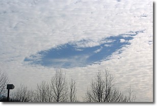
Weather Topic: What are Hole Punch Clouds?
Home - Education - Cloud Types - Hole Punch Clouds
 Next Topic: Mammatus Clouds
A hole punch cloud is an unusual occurrence when a disk-shaped
hole appears in a cirrostratus, cirrocumulus, or altocumulus cloud.
When part of the cloud forms ice crystals, water droplets in the surrounding area
of the cloud evaporate. The effect of this process produces a large elliptical
gap in the cloud. The hole punch cloud formation is rare, but it is not specific
to any geographic area.
Other names which have been used to describe this phenomena include fallstreak hole,
skypunch, and cloud hole.
Next Topic: Mammatus Clouds
Weather Topic: What are Nimbostratus Clouds?
Home - Education - Cloud Types - Nimbostratus Clouds
 Next Topic: Precipitation
A nimbostratus cloud is similar to a stratus cloud in its formless,
smooth appearance. However, a nimbostratus cloud is darker than a stratus cloud,
because it is thicker.
Unlike a stratus cloud, a nimbostratus cloud typically brings with it the threat
of moderate to heavy precipitation. In some cases, the precipitation may evaporate
before reaching the ground, a phenomenon known as virga.
Next Topic: Precipitation
Current conditions powered by WeatherAPI.com


