Weather Alert in Colorado
Avalanche Advisory issued February 27 at 5:49PM MST by NWS Denver CO
AREAS AFFECTED: Gore and Elk Mountains/Central Mountain Valleys; South and East Jackson/Larimer/North and Northeast Grand/Northwest Boulder Counties Above 9000 Feet; South and Southeast Grand/West Central and Southwest Boulder/Gilpin/Clear Creek/Summit/North and West Park Counties Above 9000 Feet; Western Mosquito Range/East Lake County Above 11000 Ft; Eastern Sawatch Mountains above 11000 Ft; Western Chaffee County Between 9000 and 11000 Ft
DESCRIPTION: SABCO THE FOLLOWING MESSAGE IS TRANSMITTED AT THE REQUEST OF THE COLORADO AVALANCHE INFORMATION CENTER. ...A SPECIAL AVALANCHE ADVISORY IN EFFECT FROM FRIDAY EVENING THROUGH SUNDAY... *WHAT...It is very easy for people to trigger large and deadly avalanches through the weekend. *WHERE...The Never Summer Mountains south over Berthoud Pass and Loveland Pass into Summit County, the Gore Range, and the northern Sawatch. *WHEN...Dangerous avalanche conditions exist through Sunday. *IMPACTS...Very large and dangerous avalanches will be easy to trigger. *PRECAUTION/PREPAREDNESS ACTIONS...These are the most dangerous conditions we have experienced all season. You can trigger a very large avalanche from a distance or from below. You may get no warning signs before you trigger a deadly avalanche. Careful planning and conservative terrain selection are essential for safe travel in backcountry avalanche terrain. Avoid travel on or under slopes steeper than 30 degrees. You can find more detailed information at colorado.gov/avalanche Pritchett
INSTRUCTION: N/A
Want more detail? Get the Complete 7 Day and Night Detailed Forecast!
Current U.S. National Radar--Current
The Current National Weather Radar is shown below with a UTC Time (subtract 5 hours from UTC to get Eastern Time).

National Weather Forecast--Current
The Current National Weather Forecast and National Weather Map are shown below.

National Weather Forecast for Tomorrow
Tomorrow National Weather Forecast and Tomorrow National Weather Map are show below.

North America Water Vapor (Moisture)
This map shows recent moisture content over North America. Bright and colored areas show high moisture (ie, clouds); brown indicates very little moisture present; black indicates no moisture.

Weather Topic: What are Nimbostratus Clouds?
Home - Education - Cloud Types - Nimbostratus Clouds
 Next Topic: Precipitation
A nimbostratus cloud is similar to a stratus cloud in its formless,
smooth appearance. However, a nimbostratus cloud is darker than a stratus cloud,
because it is thicker.
Unlike a stratus cloud, a nimbostratus cloud typically brings with it the threat
of moderate to heavy precipitation. In some cases, the precipitation may evaporate
before reaching the ground, a phenomenon known as virga.
Next Topic: Precipitation
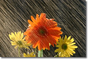
Weather Topic: What is Rain?
Home - Education - Precipitation - Rain
 Next Topic: Shelf Clouds
Precipitation in the form of water droplets is called rain.
Rain generally has a tendency to fall with less intensity over a greater period
of time, and when rainfall is more severe it is usually less sustained.
Rain is the most common form of precipitation and happens with greater frequency
depending on the season and regional influences. Cities have been shown to have
an observable effect on rainfall, due to an effect called the urban heat island.
Compared to upwind, monthly rainfall between twenty and forty miles downwind of
cities is 30% greater.
Next Topic: Shelf Clouds
Current conditions powered by WeatherAPI.com


