Weather Alert in Minnesota
Winter Storm Warning issued March 14 at 6:11AM CDT until March 16 at 1:00PM CDT by NWS La Crosse WI
AREAS AFFECTED: Dodge; Olmsted; Winona; Mower; Fillmore; Houston; La Crosse; Monroe; Juneau; Adams; Vernon
DESCRIPTION: ...MAJOR WINTER STORM TONIGHT INTO MONDAY MORNING... .A prolonged, high-impact winter storm affects the region tonight through Monday morning. Highest snow totals in excess of 12 to 18 inches are favored north of Interstate 90 with some locales north of Highway 10 approaching 24 inches. Along Interstate 90, a wintry mix of snow, freezing rain, and sleet makes it difficult to pin down exact snow and ice amounts, but impacts do warrant a Winter Storm Warning. Across northeast Iowa and southwest Wisconsin, snow does not look to arrive until Sunday afternoon, so the Winter Storm Watch is maintained for now. Increasing winds Sunday afternoon and night should result in whiteout conditions for exposed locales and an upgrade to a Blizzard Warning is likely once the exact threat area is determined. Regardless of exact snow amounts, expect major travel impacts regionwide with some roads possibly impassable, especially in wind-prone areas. * WHAT...Heavy snow, mixed with sleet and freezing rain. Total snow accumulations between 6 and 12 inches with locally higher amounts. Ice amounts around one tenth to one quarter of an inch. Winds gusting up to 50 mph may result in blizzard conditions later Sunday into Monday morning. * WHERE...Portions of southeast Minnesota and central, southwest, and west central Wisconsin. * WHEN...From 7 PM this evening to 1 PM CDT Monday. * IMPACTS...Power outages and tree damage are likely due to the ice. Travel could be nearly impossible. Widespread blowing snow could significantly reduce visibility. The hazardous conditions could impact the Monday morning commute. Gusty winds could bring down tree branches.
INSTRUCTION: If you must travel, keep an extra flashlight, food, and water in your vehicle in case of an emergency. In Minnesota, visit 511mn.org for road conditions. In Wisconsin, visit 511wi.gov for road conditions.
Want more detail? Get the Complete 7 Day and Night Detailed Forecast!
Current U.S. National Radar--Current
The Current National Weather Radar is shown below with a UTC Time (subtract 5 hours from UTC to get Eastern Time).

National Weather Forecast--Current
The Current National Weather Forecast and National Weather Map are shown below.

National Weather Forecast for Tomorrow
Tomorrow National Weather Forecast and Tomorrow National Weather Map are show below.

North America Water Vapor (Moisture)
This map shows recent moisture content over North America. Bright and colored areas show high moisture (ie, clouds); brown indicates very little moisture present; black indicates no moisture.

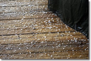
Weather Topic: What is Sleet?
Home - Education - Precipitation - Sleet
 Next Topic: Snow
Sleet is a form of precipitation in which small ice pellets are the primary
components. These ice pellets are smaller and more translucent than hailstones,
and harder than graupel. Sleet is caused by specific atmospheric conditions and
therefore typically doesn't last for extended periods of time.
The condition which leads to sleet formation requires a warmer body of air to be
wedged in between two sub-freezing bodies of air. When snow falls through a warmer
layer of air it melts, and as it falls through the next sub-freezing body of air
it freezes again, forming ice pellets known as sleet. In some cases, water
droplets don't have time to freeze before reaching the surface and the result is
freezing rain.
Next Topic: Snow
Weather Topic: What are Stratocumulus Clouds?
Home - Education - Cloud Types - Stratocumulus Clouds
 Next Topic: Stratus Clouds
Stratocumulus clouds are similar to altocumulus clouds in their
fluffy appearance, but have a slightly darker shade due to their additional mass.
A good way to distinguish the two cloud types is to hold your hand out and measure
the size of an individual cloud; if it is the size of your thumb it is generally
an altocumulus cloud, if it is the size of your hand it is generally a
stratocumulus cloud.
It is uncommon for stratocumulus clouds to produce precipitation, but if they do
it is usually a light rain or snow.
Next Topic: Stratus Clouds
Current conditions powered by WeatherAPI.com


