Weather Alert in Illinois
Flood Watch issued April 2 at 4:36AM CDT until April 5 at 5:00PM CDT by NWS Chicago IL
AREAS AFFECTED: Bureau; Putnam; La Salle
DESCRIPTION: ...The National Weather Service in Chicago IL has issued a Flood Watch for the following rivers in Illinois... Illinois River at La Salle affecting La Salle, Bureau and Putnam zones. For the Illinois River (Upper)...including Morris, Ottawa, La Salle...flooding is possible. * WHAT...Flooding is possible. * WHERE...Illinois River from Starved Rock Lock and Dam downstream to confluence with Big Bureau Creek, including the La Salle gauge. * WHEN...From late Friday night to Sunday afternoon. * IMPACTS...At 20.0 feet, Agricultural areas in La Salle, Spring Valley, and Peru are inundated. * ADDITIONAL DETAILS... - At 3:45 AM CDT Thursday the stage was 14.3 feet. - Forecast...Flood stage may be reached early Saturday morning. - Flood stage is 20.0 feet. - http://www.weather.gov/safety/flood
INSTRUCTION: A Flood Watch means water levels above flood stage are possible, but not yet certain, based upon the latest forecasts. Persons along rivers and streams in the watch area should monitor the latest forecasts and be prepared to take action should flooding develop. These forecasts are based on observed precipitation as well as forecast precipitation 24 hours into the future. Changes to the rainfall forecast, or any additional rainfall after 24 hours, may cause changes to these river forecasts. Additional information is available at www.weather.gov. The next statement will be issued by this evening.
Want more detail? Get the Complete 7 Day and Night Detailed Forecast!
Current U.S. National Radar--Current
The Current National Weather Radar is shown below with a UTC Time (subtract 5 hours from UTC to get Eastern Time).

National Weather Forecast--Current
The Current National Weather Forecast and National Weather Map are shown below.

National Weather Forecast for Tomorrow
Tomorrow National Weather Forecast and Tomorrow National Weather Map are show below.

North America Water Vapor (Moisture)
This map shows recent moisture content over North America. Bright and colored areas show high moisture (ie, clouds); brown indicates very little moisture present; black indicates no moisture.

Weather Topic: What is Sleet?
Home - Education - Precipitation - Sleet
 Next Topic: Snow
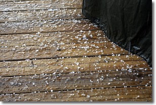
Sleet is a form of precipitation in which small ice pellets are the primary
components. These ice pellets are smaller and more translucent than hailstones,
and harder than graupel. Sleet is caused by specific atmospheric conditions and
therefore typically doesn't last for extended periods of time.
The condition which leads to sleet formation requires a warmer body of air to be
wedged in between two sub-freezing bodies of air. When snow falls through a warmer
layer of air it melts, and as it falls through the next sub-freezing body of air
it freezes again, forming ice pellets known as sleet. In some cases, water
droplets don't have time to freeze before reaching the surface and the result is
freezing rain.
Next Topic: Snow
Weather Topic: What are Stratocumulus Clouds?
Home - Education - Cloud Types - Stratocumulus Clouds
 Next Topic: Stratus Clouds
Stratocumulus clouds are similar to altocumulus clouds in their
fluffy appearance, but have a slightly darker shade due to their additional mass.
A good way to distinguish the two cloud types is to hold your hand out and measure
the size of an individual cloud; if it is the size of your thumb it is generally
an altocumulus cloud, if it is the size of your hand it is generally a
stratocumulus cloud.
It is uncommon for stratocumulus clouds to produce precipitation, but if they do
it is usually a light rain or snow.
Next Topic: Stratus Clouds
Current conditions powered by WeatherAPI.com


