Weather Alert in Georgia
Flood Warning issued February 27 at 12:36PM EST until February 27 at 11:00PM EST by NWS Peachtree City GA
AREAS AFFECTED: DeKalb, GA; Rockdale, GA
DESCRIPTION: ...The National Weather Service in Peachtree City GA has issued a Flood Warning for the following rivers in Georgia... Yellow River at Pleasant Hill Road near Lithonia affecting DeKalb and Rockdale Counties. * WHAT...Minor flooding is occurring. * WHERE...Yellow River at Pleasant Hill Road near Lithonia. * WHEN...Until late this evening. * IMPACTS...At 15.0 feet, Minor flooding continues and expands further into the woodlands and fields near the river upstream and downstream from the gage on Pleasant Hill Road. In Dekalb County... some flooding of backyards of homes begin on Harmony Hills Drive and Court. Johnson Creek flowing under Union Grove Road into the river begins to back up. * ADDITIONAL DETAILS... - At 12:15 PM EST Friday the stage was 14.0 feet. - Recent Activity...The maximum river stage in the 24 hours ending at 12:15 PM EST Friday was 14.3 feet. - Forecast...The river has crested and will continue to gradually fall below flood stage by late this evening. - Flood stage is 13.0 feet. - Flood History...This crest compares to a previous crest of 15.1 feet on 09/18/2004. - http://www.weather.gov/safety/flood
INSTRUCTION: Turn around, don't drown when encountering flooded roads. Most flood deaths occur in vehicles. Additional information is available at weather.gov/atlanta.
Want more detail? Get the Complete 7 Day and Night Detailed Forecast!
Current U.S. National Radar--Current
The Current National Weather Radar is shown below with a UTC Time (subtract 5 hours from UTC to get Eastern Time).

National Weather Forecast--Current
The Current National Weather Forecast and National Weather Map are shown below.

National Weather Forecast for Tomorrow
Tomorrow National Weather Forecast and Tomorrow National Weather Map are show below.

North America Water Vapor (Moisture)
This map shows recent moisture content over North America. Bright and colored areas show high moisture (ie, clouds); brown indicates very little moisture present; black indicates no moisture.

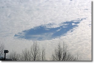
Weather Topic: What are Hole Punch Clouds?
Home - Education - Cloud Types - Hole Punch Clouds
 Next Topic: Mammatus Clouds
A hole punch cloud is an unusual occurrence when a disk-shaped
hole appears in a cirrostratus, cirrocumulus, or altocumulus cloud.
When part of the cloud forms ice crystals, water droplets in the surrounding area
of the cloud evaporate. The effect of this process produces a large elliptical
gap in the cloud. The hole punch cloud formation is rare, but it is not specific
to any geographic area.
Other names which have been used to describe this phenomena include fallstreak hole,
skypunch, and cloud hole.
Next Topic: Mammatus Clouds
Weather Topic: What are Nimbostratus Clouds?
Home - Education - Cloud Types - Nimbostratus Clouds
 Next Topic: Precipitation
A nimbostratus cloud is similar to a stratus cloud in its formless,
smooth appearance. However, a nimbostratus cloud is darker than a stratus cloud,
because it is thicker.
Unlike a stratus cloud, a nimbostratus cloud typically brings with it the threat
of moderate to heavy precipitation. In some cases, the precipitation may evaporate
before reaching the ground, a phenomenon known as virga.
Next Topic: Precipitation
Current conditions powered by WeatherAPI.com


