Weather Alert in Oregon
Flood Warning issued March 14 at 2:33AM PDT by NWS Portland OR
AREAS AFFECTED: Clackamas, OR; Multnomah, OR
DESCRIPTION: ...The Flood Warning is extended for the following rivers in Oregon...Washington... Nehalem River near Foss affecting Clatsop and Tillamook Counties. Wilson River near Tillamook affecting Tillamook County. Cowlitz River at Kelso affecting Cowlitz County. Grays River at Covered Bridge near Rosburg affecting Wahkiakum County. Johnson Creek at Sycamore affecting Clackamas and Multnomah Counties. * WHAT...Minor flooding is forecast. * WHERE...Johnson Creek at Sycamore. * WHEN...Until further notice. * IMPACTS...Above 11.0 feet, minor flooding begins along Johnson Creek between SE 92nd Street to SE 122nd Street and between Johnson Creek and SE Harold Street. * ADDITIONAL DETAILS... - At 2:00 AM PDT Saturday the stage was 8.1 feet. - Bankfull stage is 10.0 feet. - Forecast...The river will rise above flood stage to 11.1 feet early this morning. It will then fall below flood stage Saturday afternoon. - Flood stage is 11.0 feet. - http://www.weather.gov/safety/flood
INSTRUCTION: Motorists should not attempt to drive around barricades or drive through flooded areas. Be especially cautious at night when it is harder to recognize the dangers of flooding. Turn around, don't drown when encountering flooded roads. Most flood deaths occur in vehicles. Additional information is available at www.weather.gov. The next statement will be issued early Saturday morning at 600 AM PDT.this morning at 600 AM PDT.
Want more detail? Get the Complete 7 Day and Night Detailed Forecast!
Current U.S. National Radar--Current
The Current National Weather Radar is shown below with a UTC Time (subtract 5 hours from UTC to get Eastern Time).

National Weather Forecast--Current
The Current National Weather Forecast and National Weather Map are shown below.

National Weather Forecast for Tomorrow
Tomorrow National Weather Forecast and Tomorrow National Weather Map are show below.

North America Water Vapor (Moisture)
This map shows recent moisture content over North America. Bright and colored areas show high moisture (ie, clouds); brown indicates very little moisture present; black indicates no moisture.

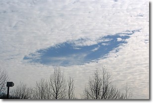
Weather Topic: What are Hole Punch Clouds?
Home - Education - Cloud Types - Hole Punch Clouds
 Next Topic: Mammatus Clouds
A hole punch cloud is an unusual occurrence when a disk-shaped
hole appears in a cirrostratus, cirrocumulus, or altocumulus cloud.
When part of the cloud forms ice crystals, water droplets in the surrounding area
of the cloud evaporate. The effect of this process produces a large elliptical
gap in the cloud. The hole punch cloud formation is rare, but it is not specific
to any geographic area.
Other names which have been used to describe this phenomena include fallstreak hole,
skypunch, and cloud hole.
Next Topic: Mammatus Clouds
Weather Topic: What are Nimbostratus Clouds?
Home - Education - Cloud Types - Nimbostratus Clouds
 Next Topic: Precipitation
A nimbostratus cloud is similar to a stratus cloud in its formless,
smooth appearance. However, a nimbostratus cloud is darker than a stratus cloud,
because it is thicker.
Unlike a stratus cloud, a nimbostratus cloud typically brings with it the threat
of moderate to heavy precipitation. In some cases, the precipitation may evaporate
before reaching the ground, a phenomenon known as virga.
Next Topic: Precipitation
Current conditions powered by WeatherAPI.com


