Weather Alert in Nebraska
Fire Weather Watch issued March 10 at 2:20PM CDT until March 12 at 10:00PM CDT by NWS North Platte NE
AREAS AFFECTED: Eastern Panhandle/Crescent Lake NWR; Sandhills/Valentine NWR/Nebraska National Forest; Niobrara Valley/Fort Niobrara NWR/Samuel R McKelvie National Forest; Loup Rivers Basin; Frenchman Basin; Loess Plains
DESCRIPTION: ...Dangerous Fire Weather Conditions Possible Thursday... The National Weather Service in North Platte has issued a Fire Weather Watch for low humidity, warm temperatures, very strong westerly winds, which is in effect from Thursday afternoon through Thursday evening. * AFFECTED AREA...Fire Weather Zone 204 Eastern Panhandle/Crescent Lake NWR, Fire Weather Zone 206 Sandhills/Valentine NWR/Nebraska National Forest, Fire Weather Zone 208 Niobrara Valley/Fort Niobrara NWR/Samuel R McKelvie National Forest, Fire Weather Zone 209 Loup Rivers Basin, Fire Weather Zone 210 Frenchman Basin and Fire Weather Zone 219 Loess Plains. * TIMING...12 PM CDT/ 11 AM MDT to 10 PM CDT/ 9 PM MDT Monday * WINDS...West 30 to 40 mph with gusts up to 65 mph. * RELATIVE HUMIDITY...As low as 15 percent. * TEMPERATURES...70 to 76. * LIGHTNING...None expected. * IMPACTS...Any fire starts will have a high potential to spread rapidly and will be difficult to control.
INSTRUCTION: A Fire Weather Watch means that critical fire weather conditions are forecast to occur. Listen for later forecasts and possible Red Flag Warnings.
Want more detail? Get the Complete 7 Day and Night Detailed Forecast!
Current U.S. National Radar--Current
The Current National Weather Radar is shown below with a UTC Time (subtract 5 hours from UTC to get Eastern Time).

National Weather Forecast--Current
The Current National Weather Forecast and National Weather Map are shown below.

National Weather Forecast for Tomorrow
Tomorrow National Weather Forecast and Tomorrow National Weather Map are show below.

North America Water Vapor (Moisture)
This map shows recent moisture content over North America. Bright and colored areas show high moisture (ie, clouds); brown indicates very little moisture present; black indicates no moisture.

Weather Topic: What are Nimbostratus Clouds?
Home - Education - Cloud Types - Nimbostratus Clouds
 Next Topic: Precipitation
A nimbostratus cloud is similar to a stratus cloud in its formless,
smooth appearance. However, a nimbostratus cloud is darker than a stratus cloud,
because it is thicker.
Unlike a stratus cloud, a nimbostratus cloud typically brings with it the threat
of moderate to heavy precipitation. In some cases, the precipitation may evaporate
before reaching the ground, a phenomenon known as virga.
Next Topic: Precipitation
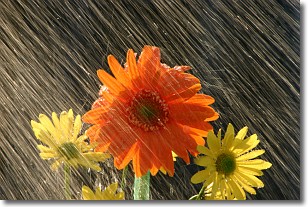
Weather Topic: What is Rain?
Home - Education - Precipitation - Rain
 Next Topic: Shelf Clouds
Precipitation in the form of water droplets is called rain.
Rain generally has a tendency to fall with less intensity over a greater period
of time, and when rainfall is more severe it is usually less sustained.
Rain is the most common form of precipitation and happens with greater frequency
depending on the season and regional influences. Cities have been shown to have
an observable effect on rainfall, due to an effect called the urban heat island.
Compared to upwind, monthly rainfall between twenty and forty miles downwind of
cities is 30% greater.
Next Topic: Shelf Clouds
Current conditions powered by WeatherAPI.com


