Weather Alert in California
Red Flag Warning issued August 23 at 8:56AM PDT until August 23 at 9:00PM PDT by NWS Los Angeles/Oxnard CA
AREAS AFFECTED: Cuyama Valley; Santa Clarita Valley; San Luis Obispo County Mountains; Santa Ynez Mountains Western Range; Santa Ynez Mountains Eastern Range; Santa Barbara County Interior Mountains; Santa Susana Mountains; Southern Ventura County Mountains; Northern Ventura County Mountains; Interstate 5 Corridor; Western San Gabriel Mountains and Highway 14 Corridor; Eastern San Gabriel Mountains; Western Antelope Valley Foothills; Eastern Antelope Valley Foothills
DESCRIPTION: ...RED FLAG WARNING IN EFFECT UNTIL 9 PM PDT THIS EVENING FOR AN UNSEASONABLY HOT AND UNSTABLE AIR MASS CAPABLE OF PRODUCING EXTREME FIRE BEHAVIOR FROM VERTICAL PLUME GROWTH, LOW RELATIVE HUMIDITY, LOCALLY GUSTY WINDS, ISOLATED DRY LIGHTNING STRIKES, AND CRITICALLY DRY FUELS FOR PORTIONS OF THE MOUNTAINS AND FOOTHILLS OF LOS ANGELES, VENTURA, SANTA BARBARA, AND SAN LUIS OBISPO COUNTIES... .A significant heatwave and increased instability, along with isolated dry lightning strikes and gusty outflow winds will continue, bringing dangerous fire-weather conditions. * TEMPERATURES...Unseasonably hot conditions with high temperatures of 95 to 105 degrees, producing unseasonably unstable conditions, with deep mixing heights of 12,000 to 18,000 feet. * RELATIVE HUMIDITY...Minimum relative humidity 12 to 25 percent, except 25 to 40 percent across higher mountains. * THUNDERSTORMS...Scattered thunderstorms at times will be capable of producing dry lightning fire starts as well as strong downburst/outflow winds gusting to 30 to 50 mph. * WINDS...Outside of thunderstorms, southwest winds of 10 to 20 mph gusting to 20 to 30 mph are expected, strongest in the afternoon hours and in the San Gabriel Mountains and Antelope Valley foothills. * IMPACTS...If fire ignition occurs, conditions are favorable for extreme fire behavior and rapid fire growth, which could threaten life and property. Be aware of sudden re-direction of fires in response to passing outflow boundaries. * ADDITIONAL DETAILS...While the dangerous threat for plume dominated fires and dry lightning strikes will likely continue through at least Monday, the threat will decrease some after today. As such, unless expected conditions change drastically, this Red Flag Warning will be allowed to expire this evening with no plans on extending.
INSTRUCTION: A Red Flag Warning means that fire-weather conditions could potentially become favorable for the development of extreme fire behavior. Use extreme caution with anything that can spark a wildfire. Residents near wildland interfaces should be prepared to evacuate if a wildfire breaks out. See readyforwildfire.org and wildfirerisk.org for more information.
Want more detail? Get the Complete 7 Day and Night Detailed Forecast!
Current U.S. National Radar--Current
The Current National Weather Radar is shown below with a UTC Time (subtract 5 hours from UTC to get Eastern Time).

National Weather Forecast--Current
The Current National Weather Forecast and National Weather Map are shown below.

National Weather Forecast for Tomorrow
Tomorrow National Weather Forecast and Tomorrow National Weather Map are show below.

North America Water Vapor (Moisture)
This map shows recent moisture content over North America. Bright and colored areas show high moisture (ie, clouds); brown indicates very little moisture present; black indicates no moisture.

Weather Topic: What are Cirrocumulus Clouds?
Home - Education - Cloud Types - Cirrocumulus Clouds
 Next Topic: Cirrostratus Clouds
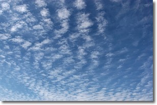
Cirrocumulus clouds form at high altitudes (usually around 5 km)
and have distinguishing characteristics displayed in a fine layer of
small cloud patches. These small cloud patches are sometimes referred to as
"cloudlets" in relation to the whole cloud formation.
Cirrocumulus clouds are formed from ice crystals and water droplets. Often, the
water droplets in the cloud freeze into ice crystals and the cloud becomes a
cirrostratus cloud. Because of this common occurrence, cirrocumulus cloud
formations generally pass rapidly.
Next Topic: Cirrostratus Clouds
Weather Topic: What are Cirrus Clouds?
Home - Education - Cloud Types - Cirrus Clouds
 Next Topic: Condensation
Cirrus clouds are high-level clouds that occur above 20,000 feet
and are composed mainly of ice crystals.
They are thin and wispy in appearance.
What do they indicate?
They are often the first sign of an approaching storm.
Next Topic: Condensation
Current conditions powered by WeatherAPI.com


