Weather Alert in North Carolina
Flood Advisory issued June 14 at 9:35PM EDT until June 14 at 11:15PM EDT by NWS Greenville-Spartanburg SC
AREAS AFFECTED: Alexander, NC; Caldwell, NC
DESCRIPTION: * WHAT...Flooding caused by excessive rainfall continues. * WHERE...Portions of piedmont and western North Carolina, including the following counties, in piedmont North Carolina, Alexander. In western North Carolina, Caldwell. * WHEN...Until 1115 PM EDT. * IMPACTS...Minor flooding in low-lying and poor drainage areas. Water over roadways. Ponding of water in urban or other areas is occurring or is imminent. * ADDITIONAL DETAILS... - At 932 PM EDT, Doppler radar indicated heavy rain due to thunderstorms. Minor flooding is ongoing or expected to begin shortly in the advisory area. Between 2 and 4 inches of rain have fallen. - Middle Road between Paul Payne Store Rd and Johnny Martin Ln is closed due to flooding. Other roads may be flooded in southeastern Alexander County, especially along Elk Shoals Creek and its tributaries. High water may also be flooding sections of Lower Creek south of Lenoir. - Some locations that will experience flooding include... Hickory, Lenoir, Taylorsville, Sawmills, Granite Falls, Gamewell, Bethlehem, Hudson, Cajah's Mountain, Stony Point, Rhodhiss, Cedar Rock, Lake Hickory, Lake Rhodhiss, Lookout Shoals Lake, Little River In Alexander County, Ellendale, Northlakes, Kings Creek and Millersville. - http://www.weather.gov/safety/flood
INSTRUCTION: When it is safe to do so, please report flooding or landslides threatening roads or property to the National Weather Service Greenville-Spartanburg by calling toll free, 1, 800, 2 6 7, 8 1 0 1, by posting on our Facebook page, or via X using hashtag NWSGSP. Your message should describe the specific location where impacts occurred and the depth of flooding observed. Be especially cautious at night when it is harder to recognize the dangers of flooding. Be aware of your surroundings and do not drive on flooded roads.
Want more detail? Get the Complete 7 Day and Night Detailed Forecast!
Current U.S. National Radar--Current
The Current National Weather Radar is shown below with a UTC Time (subtract 5 hours from UTC to get Eastern Time).

National Weather Forecast--Current
The Current National Weather Forecast and National Weather Map are shown below.

National Weather Forecast for Tomorrow
Tomorrow National Weather Forecast and Tomorrow National Weather Map are show below.

North America Water Vapor (Moisture)
This map shows recent moisture content over North America. Bright and colored areas show high moisture (ie, clouds); brown indicates very little moisture present; black indicates no moisture.

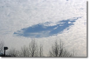
Weather Topic: What are Hole Punch Clouds?
Home - Education - Cloud Types - Hole Punch Clouds
 Next Topic: Mammatus Clouds
A hole punch cloud is an unusual occurrence when a disk-shaped
hole appears in a cirrostratus, cirrocumulus, or altocumulus cloud.
When part of the cloud forms ice crystals, water droplets in the surrounding area
of the cloud evaporate. The effect of this process produces a large elliptical
gap in the cloud. The hole punch cloud formation is rare, but it is not specific
to any geographic area.
Other names which have been used to describe this phenomena include fallstreak hole,
skypunch, and cloud hole.
Next Topic: Mammatus Clouds
Weather Topic: What are Nimbostratus Clouds?
Home - Education - Cloud Types - Nimbostratus Clouds
 Next Topic: Precipitation
A nimbostratus cloud is similar to a stratus cloud in its formless,
smooth appearance. However, a nimbostratus cloud is darker than a stratus cloud,
because it is thicker.
Unlike a stratus cloud, a nimbostratus cloud typically brings with it the threat
of moderate to heavy precipitation. In some cases, the precipitation may evaporate
before reaching the ground, a phenomenon known as virga.
Next Topic: Precipitation
Current conditions powered by WeatherAPI.com


