Weather Alert in Montana
Winter Storm Warning issued April 2 at 12:05AM MDT until April 3 at 12:00PM MDT by NWS Great Falls MT
AREAS AFFECTED: Big Belt, Bridger and Castle Mountains
DESCRIPTION: * WHAT...Heavy snow expected. Total snow accumulations between 6 and 10 inches over Bozeman and Battle Ridge Passes. Winds gusting as high as 40 mph will create areas of blowing snow Thursday evening and overnight. * WHERE...Big Belt, Bridger and Castle Mountains. * WHEN...From 9 AM Thursday to noon MDT Friday. * IMPACTS...Travel could be very difficult and tire chains may be required for some vehicles. * ADDITIONAL DETAILS...Snow accumulation on road surfaces may be limited through Thursday afternoon with increasing chances for travel impacts from snow accumulation and wind Thursday evening.
INSTRUCTION: If you must travel, keep an extra flashlight, food, and water in your vehicle in case of an emergency. The latest road conditions can be obtained by calling 5 1 1 or visiting the MDT Road Report website. Remember, a Winter Storm Warning means that there is at least an 80% chance of impactful winter weather conditions during the warning period.
Want more detail? Get the Complete 7 Day and Night Detailed Forecast!
Current U.S. National Radar--Current
The Current National Weather Radar is shown below with a UTC Time (subtract 5 hours from UTC to get Eastern Time).

National Weather Forecast--Current
The Current National Weather Forecast and National Weather Map are shown below.

National Weather Forecast for Tomorrow
Tomorrow National Weather Forecast and Tomorrow National Weather Map are show below.

North America Water Vapor (Moisture)
This map shows recent moisture content over North America. Bright and colored areas show high moisture (ie, clouds); brown indicates very little moisture present; black indicates no moisture.

Weather Topic: What is Graupel?
Home - Education - Precipitation - Graupel
 Next Topic: Hail
Graupel is a form of precipitation that is created by atmospheric conditions
which cause supercooled water droplets to contact snow crystals and freeze to
their surface.
Sometimes known as soft hail or snow pellets, graupel is delicate and easily
destroyed by touch. Whereas hail usually falls during severe weather, graupel
doesn't require such conditions to form, and can form in mild precipitation
similar to situations which produce snowfall.
Next Topic: Hail
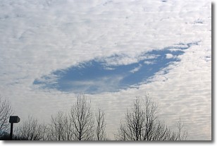
Weather Topic: What are Hole Punch Clouds?
Home - Education - Cloud Types - Hole Punch Clouds
 Next Topic: Mammatus Clouds
A hole punch cloud is an unusual occurrence when a disk-shaped
hole appears in a cirrostratus, cirrocumulus, or altocumulus cloud.
When part of the cloud forms ice crystals, water droplets in the surrounding area
of the cloud evaporate. The effect of this process produces a large elliptical
gap in the cloud. The hole punch cloud formation is rare, but it is not specific
to any geographic area.
Other names which have been used to describe this phenomena include fallstreak hole,
skypunch, and cloud hole.
Next Topic: Mammatus Clouds
Current conditions powered by WeatherAPI.com


