Weather Alert in Illinois
Flood Warning issued March 13 at 10:32PM EDT until March 20 at 4:24AM EDT by NWS Indianapolis IN
AREAS AFFECTED: Edwards, IL; Gallatin, IL; Wabash, IL; White, IL; Gibson, IN; Knox, IN; Posey, IN
DESCRIPTION: ...The Flood Warning continues for the following rivers in Indiana... Illinois... East Fork White River at Seymour downriver through Shoals. White River at Petersburg and at Hazleton. Wabash River at Mount Carmel. ...The Flood Warning is extended for the following rivers in Indiana... White River at Edwardsport. .Moderate flooding in progress on the lower White River at Petersburg and Hazleton will continue through next Monday. Minor flooding on the White River from Edwardsport will continue into Monday...with minor flooding of lowland areas persisting at Petersburg and Hazleton through next week. Minor Flooding on the East Fork White from Seymour down to Shoals will continue into early next week. Minor flooding on the Wabash at Mount Carmel will continue into later next week. * WHAT...Minor flooding is occurring and minor flooding is forecast. * WHERE...Wabash River at Mount Carmel. * WHEN...Until Friday, March 20. * IMPACTS...At 23.9 feet, Extensive lowland flooding in progress. In Wabash County Illinois, South Division Street and 1.5 miles of CR 1280 E remain flooded. High water blocks access to cabins along South Division Street and some nearby oil fields. * ADDITIONAL DETAILS... - At 9:45 PM EDT Friday /8:45 PM CDT Friday/ the stage was 23.4 feet. - Recent Activity...The maximum river stage in the 24 hours ending at 9:45 PM EDT Friday /8:45 PM CDT Friday/ was 23.4 feet. - Forecast...The river is expected to rise to a crest of 23.5 feet early tomorrow afternoon. It will then fall below flood stage Thursday afternoon. - Flood stage is 19.0 feet. - http://www.weather.gov/safety/flood
INSTRUCTION: Motorists should not attempt to drive around barricades or drive cars through flooded areas. Caution is urged when walking near riverbanks. Additional information is available at www.weather.gov/ind. The next statement should be issued Saturday afternoon by around 100 PM EDT /noon CDT/.
Want more detail? Get the Complete 7 Day and Night Detailed Forecast!
Current U.S. National Radar--Current
The Current National Weather Radar is shown below with a UTC Time (subtract 5 hours from UTC to get Eastern Time).

National Weather Forecast--Current
The Current National Weather Forecast and National Weather Map are shown below.

National Weather Forecast for Tomorrow
Tomorrow National Weather Forecast and Tomorrow National Weather Map are show below.

North America Water Vapor (Moisture)
This map shows recent moisture content over North America. Bright and colored areas show high moisture (ie, clouds); brown indicates very little moisture present; black indicates no moisture.

Weather Topic: What is Sleet?
Home - Education - Precipitation - Sleet
 Next Topic: Snow
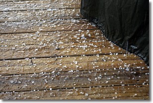
Sleet is a form of precipitation in which small ice pellets are the primary
components. These ice pellets are smaller and more translucent than hailstones,
and harder than graupel. Sleet is caused by specific atmospheric conditions and
therefore typically doesn't last for extended periods of time.
The condition which leads to sleet formation requires a warmer body of air to be
wedged in between two sub-freezing bodies of air. When snow falls through a warmer
layer of air it melts, and as it falls through the next sub-freezing body of air
it freezes again, forming ice pellets known as sleet. In some cases, water
droplets don't have time to freeze before reaching the surface and the result is
freezing rain.
Next Topic: Snow
Weather Topic: What are Stratocumulus Clouds?
Home - Education - Cloud Types - Stratocumulus Clouds
 Next Topic: Stratus Clouds
Stratocumulus clouds are similar to altocumulus clouds in their
fluffy appearance, but have a slightly darker shade due to their additional mass.
A good way to distinguish the two cloud types is to hold your hand out and measure
the size of an individual cloud; if it is the size of your thumb it is generally
an altocumulus cloud, if it is the size of your hand it is generally a
stratocumulus cloud.
It is uncommon for stratocumulus clouds to produce precipitation, but if they do
it is usually a light rain or snow.
Next Topic: Stratus Clouds
Current conditions powered by WeatherAPI.com


