Weather Alert in New Jersey
Coastal Flood Watch issued February 20 at 3:50PM EST until February 23 at 5:00AM EST by NWS Mount Holly NJ
AREAS AFFECTED: Middlesex; Western Monmouth; Eastern Monmouth
DESCRIPTION: * WHAT...One to two feet of inundation above ground level possible in low-lying areas near shorelines and tidal waterways. * WHERE...Middlesex, Western Monmouth and Eastern Monmouth. * WHEN...From Sunday evening through late Sunday night. * IMPACTS...At this level, widespread roadway flooding occurs in coastal and bayside communities and along inland tidal waterways. Many roads become impassable. Some damage to vulnerable structures may begin to occur. * ADDITIONAL DETAILS...Additional coastal flooding may linger into Monday's high tide cycles.
INSTRUCTION: A Coastal Flood Watch means that conditions favorable for flooding are expected to develop. Be prepared to begin taking appropriate action to protect life and property. Follow the recommendations of local emergency management officials. Be sure to check the latest forecast from time to time in case a warning is issued or any new information becomes available. Visit the National Water Prediction Service at https://water.noaa.gov/wfo/phi for additional water level and flood impact information for your local tide gauge.
Want more detail? Get the Complete 7 Day and Night Detailed Forecast!
Current U.S. National Radar--Current
The Current National Weather Radar is shown below with a UTC Time (subtract 5 hours from UTC to get Eastern Time).

National Weather Forecast--Current
The Current National Weather Forecast and National Weather Map are shown below.

National Weather Forecast for Tomorrow
Tomorrow National Weather Forecast and Tomorrow National Weather Map are show below.

North America Water Vapor (Moisture)
This map shows recent moisture content over North America. Bright and colored areas show high moisture (ie, clouds); brown indicates very little moisture present; black indicates no moisture.

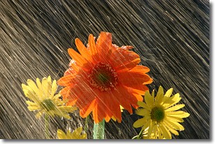
Weather Topic: What is Rain?
Home - Education - Precipitation - Rain
 Next Topic: Shelf Clouds
Precipitation in the form of water droplets is called rain.
Rain generally has a tendency to fall with less intensity over a greater period
of time, and when rainfall is more severe it is usually less sustained.
Rain is the most common form of precipitation and happens with greater frequency
depending on the season and regional influences. Cities have been shown to have
an observable effect on rainfall, due to an effect called the urban heat island.
Compared to upwind, monthly rainfall between twenty and forty miles downwind of
cities is 30% greater.
Next Topic: Shelf Clouds
Weather Topic: What is Sleet?
Home - Education - Precipitation - Sleet
 Next Topic: Snow
Sleet is a form of precipitation in which small ice pellets are the primary
components. These ice pellets are smaller and more translucent than hailstones,
and harder than graupel. Sleet is caused by specific atmospheric conditions and
therefore typically doesn't last for extended periods of time.
The condition which leads to sleet formation requires a warmer body of air to be
wedged in between two sub-freezing bodies of air. When snow falls through a warmer
layer of air it melts, and as it falls through the next sub-freezing body of air
it freezes again, forming ice pellets known as sleet. In some cases, water
droplets don't have time to freeze before reaching the surface and the result is
freezing rain.
Next Topic: Snow
Current conditions powered by WeatherAPI.com


