Weather Alert in Florida
Special Weather Statement issued March 10 at 5:10AM EDT by NWS Tampa Bay Ruskin FL
AREAS AFFECTED: Coastal Levy; Coastal Citrus; Inland Levy; Inland Citrus
DESCRIPTION: At 508 AM EDT, satellite imagery and surface observations indicate areas of patchy dense fog with visibilities at or below one mile. Locations impacted include... Williston Highlands, Arbor Lakes, Lecanto, Homosassa Springs, East Bronson, Otter Creek, Citronelle, Leisure Acres, Inglis, Inverness Highlands, Inverness Airport, Crystal River Airport, Manattee Road, Pine Ridge, Bronson, Heatherwood, Citrus Hills, Gospel Island, Fowlers Bluff, and Black Diamond. Motorists should be prepared for sudden changes in visibility. Use low beam headlights, reduce your speed, and maintain a safe distance between your vehicle and the one ahead of you.
INSTRUCTION: N/A
Want more detail? Get the Complete 7 Day and Night Detailed Forecast!
Current U.S. National Radar--Current
The Current National Weather Radar is shown below with a UTC Time (subtract 5 hours from UTC to get Eastern Time).

National Weather Forecast--Current
The Current National Weather Forecast and National Weather Map are shown below.

National Weather Forecast for Tomorrow
Tomorrow National Weather Forecast and Tomorrow National Weather Map are show below.

North America Water Vapor (Moisture)
This map shows recent moisture content over North America. Bright and colored areas show high moisture (ie, clouds); brown indicates very little moisture present; black indicates no moisture.

Weather Topic: What is Sleet?
Home - Education - Precipitation - Sleet
 Next Topic: Snow
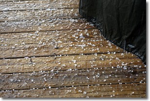
Sleet is a form of precipitation in which small ice pellets are the primary
components. These ice pellets are smaller and more translucent than hailstones,
and harder than graupel. Sleet is caused by specific atmospheric conditions and
therefore typically doesn't last for extended periods of time.
The condition which leads to sleet formation requires a warmer body of air to be
wedged in between two sub-freezing bodies of air. When snow falls through a warmer
layer of air it melts, and as it falls through the next sub-freezing body of air
it freezes again, forming ice pellets known as sleet. In some cases, water
droplets don't have time to freeze before reaching the surface and the result is
freezing rain.
Next Topic: Snow
Weather Topic: What are Stratocumulus Clouds?
Home - Education - Cloud Types - Stratocumulus Clouds
 Next Topic: Stratus Clouds
Stratocumulus clouds are similar to altocumulus clouds in their
fluffy appearance, but have a slightly darker shade due to their additional mass.
A good way to distinguish the two cloud types is to hold your hand out and measure
the size of an individual cloud; if it is the size of your thumb it is generally
an altocumulus cloud, if it is the size of your hand it is generally a
stratocumulus cloud.
It is uncommon for stratocumulus clouds to produce precipitation, but if they do
it is usually a light rain or snow.
Next Topic: Stratus Clouds
Current conditions powered by WeatherAPI.com


