Weather Alert in New Mexico
Wind Advisory issued February 18 at 5:13AM MST until February 18 at 8:00PM MST by NWS Albuquerque NM
AREAS AFFECTED: Northwest Plateau; Far Northwest Highlands; Northwest Highlands; West Central Mountains; West Central Highlands; San Francisco River Valley; Jemez Mountains; Upper Rio Grande Valley; Espanola Valley; Santa Fe Metro Area; Middle Rio Grande Valley/Albuquerque Metro Area; Lower Rio Grande Valley; Sandia/Manzano Mountains Including Edgewood; Estancia Valley; South Central Highlands; Upper Tularosa Valley; San Agustin Plains and Adjacent Lowlands
DESCRIPTION: * WHAT...Southwest winds 25 to 35 mph with gusts up to 55 mph expected. * WHERE...Portions of western and central New Mexico, including the Albuquerque and Santa Fe metro areas. * WHEN...From 11 AM this morning to 8 PM MST this evening. * IMPACTS...Gusty winds will blow around unsecured objects. Tree limbs may be blown down. Expect strong crosswinds on area roadways. * ADDITIONAL DETAILS...This afternoon and early evening, there is a moderately high probability of snow squalls along and west of the Tusas and Jemez Mountains capable of producing brief periods of near zero visibility, a flash freeze, and a quick inch or two of snow that will make driving treacherous.
INSTRUCTION: Take action to secure trash cans, lawn furniture, and other loose or lightweight outdoor objects. Dangerous driving conditions can be expected, especially for motorists in high profile vehicles.
Want more detail? Get the Complete 7 Day and Night Detailed Forecast!
Current U.S. National Radar--Current
The Current National Weather Radar is shown below with a UTC Time (subtract 5 hours from UTC to get Eastern Time).

National Weather Forecast--Current
The Current National Weather Forecast and National Weather Map are shown below.

National Weather Forecast for Tomorrow
Tomorrow National Weather Forecast and Tomorrow National Weather Map are show below.

North America Water Vapor (Moisture)
This map shows recent moisture content over North America. Bright and colored areas show high moisture (ie, clouds); brown indicates very little moisture present; black indicates no moisture.

Weather Topic: What is Graupel?
Home - Education - Precipitation - Graupel
 Next Topic: Hail
Graupel is a form of precipitation that is created by atmospheric conditions
which cause supercooled water droplets to contact snow crystals and freeze to
their surface.
Sometimes known as soft hail or snow pellets, graupel is delicate and easily
destroyed by touch. Whereas hail usually falls during severe weather, graupel
doesn't require such conditions to form, and can form in mild precipitation
similar to situations which produce snowfall.
Next Topic: Hail
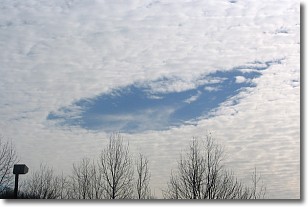
Weather Topic: What are Hole Punch Clouds?
Home - Education - Cloud Types - Hole Punch Clouds
 Next Topic: Mammatus Clouds
A hole punch cloud is an unusual occurrence when a disk-shaped
hole appears in a cirrostratus, cirrocumulus, or altocumulus cloud.
When part of the cloud forms ice crystals, water droplets in the surrounding area
of the cloud evaporate. The effect of this process produces a large elliptical
gap in the cloud. The hole punch cloud formation is rare, but it is not specific
to any geographic area.
Other names which have been used to describe this phenomena include fallstreak hole,
skypunch, and cloud hole.
Next Topic: Mammatus Clouds
Current conditions powered by WeatherAPI.com


