Weather Alert in New Mexico
High Wind Warning issued February 18 at 5:13AM MST until February 19 at 5:00AM MST by NWS Albuquerque NM
AREAS AFFECTED: Glorieta Mesa Including Glorieta Pass; Northern Sangre de Cristo Mountains; Southern Sangre de Cristo Mountains; East Slopes Sangre de Cristo Mountains; Central Highlands; South Central Mountains; Johnson and Bartlett Mesas Including Raton Pass; Far Northeast Highlands; Northeast Highlands; Guadalupe County; Eastern Lincoln County; Southwest Chaves County
DESCRIPTION: * WHAT...West winds 30 to 40 mph with gusts up to 60 mph expected. * WHERE...Portions of central, east central, north central, northeast, and southeast New Mexico along and just east of the central mountain chain, as well as Guadalupe County. * WHEN...From 11 AM this morning to 5 AM MST Thursday. * IMPACTS...Damaging winds could blow down trees and power lines. Power outages are possible. Travel will be difficult, especially for high profile vehicles. * ADDITIONAL DETAILS...A few inches of snow are forecast in the Sangre de Cristo Mountains this afternoon. Periods of snow and blowing snow will drop visibility below a half mile at times. Snow drifts will reach over 6 inches in spots.
INSTRUCTION: Take action to secure trash cans, lawn furniture, and other loose or lightweight outdoor objects. Dangerous driving conditions can be expected, especially for motorists in high profile vehicles.
Want more detail? Get the Complete 7 Day and Night Detailed Forecast!
Current U.S. National Radar--Current
The Current National Weather Radar is shown below with a UTC Time (subtract 5 hours from UTC to get Eastern Time).

National Weather Forecast--Current
The Current National Weather Forecast and National Weather Map are shown below.

National Weather Forecast for Tomorrow
Tomorrow National Weather Forecast and Tomorrow National Weather Map are show below.

North America Water Vapor (Moisture)
This map shows recent moisture content over North America. Bright and colored areas show high moisture (ie, clouds); brown indicates very little moisture present; black indicates no moisture.

Weather Topic: What are Nimbostratus Clouds?
Home - Education - Cloud Types - Nimbostratus Clouds
 Next Topic: Precipitation
A nimbostratus cloud is similar to a stratus cloud in its formless,
smooth appearance. However, a nimbostratus cloud is darker than a stratus cloud,
because it is thicker.
Unlike a stratus cloud, a nimbostratus cloud typically brings with it the threat
of moderate to heavy precipitation. In some cases, the precipitation may evaporate
before reaching the ground, a phenomenon known as virga.
Next Topic: Precipitation
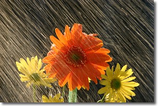
Weather Topic: What is Rain?
Home - Education - Precipitation - Rain
 Next Topic: Shelf Clouds
Precipitation in the form of water droplets is called rain.
Rain generally has a tendency to fall with less intensity over a greater period
of time, and when rainfall is more severe it is usually less sustained.
Rain is the most common form of precipitation and happens with greater frequency
depending on the season and regional influences. Cities have been shown to have
an observable effect on rainfall, due to an effect called the urban heat island.
Compared to upwind, monthly rainfall between twenty and forty miles downwind of
cities is 30% greater.
Next Topic: Shelf Clouds
Current conditions powered by WeatherAPI.com


