Weather Alert in Idaho
High Wind Warning issued March 13 at 8:37PM MDT until March 14 at 9:00PM MDT by NWS Pocatello ID
AREAS AFFECTED: Arco/Mud Lake Desert; Lower Snake River Plain; Teton Valley
DESCRIPTION: * WHAT...West winds 40 to 50 mph with gusts up to 65 mph expected. * WHERE...Teton Valley, Arco/Mud Lake Desert, and Lower Snake River Plain. * WHEN...From 9 AM to 9 PM MDT Saturday. * IMPACTS...Travel will be difficult, especially for high profile vehicles. Isolated damage to trees, powerlines, signs, and outbuildings is expected, along with isolated power outages. Loose outdoor objects will be blown around.
INSTRUCTION: Secure or bring inside loose outdoor objects before the high winds begin. During the high winds, avoid being outside in forested areas or around trees, branches, and powerlines. Use caution if you must drive, and keep both hands firmly on the steering wheel. Drivers of high profile vehicles should consider delaying travel until the high winds subside.
Want more detail? Get the Complete 7 Day and Night Detailed Forecast!
Current U.S. National Radar--Current
The Current National Weather Radar is shown below with a UTC Time (subtract 5 hours from UTC to get Eastern Time).

National Weather Forecast--Current
The Current National Weather Forecast and National Weather Map are shown below.

National Weather Forecast for Tomorrow
Tomorrow National Weather Forecast and Tomorrow National Weather Map are show below.

North America Water Vapor (Moisture)
This map shows recent moisture content over North America. Bright and colored areas show high moisture (ie, clouds); brown indicates very little moisture present; black indicates no moisture.

Weather Topic: What is Graupel?
Home - Education - Precipitation - Graupel
 Next Topic: Hail
Graupel is a form of precipitation that is created by atmospheric conditions
which cause supercooled water droplets to contact snow crystals and freeze to
their surface.
Sometimes known as soft hail or snow pellets, graupel is delicate and easily
destroyed by touch. Whereas hail usually falls during severe weather, graupel
doesn't require such conditions to form, and can form in mild precipitation
similar to situations which produce snowfall.
Next Topic: Hail
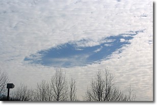
Weather Topic: What are Hole Punch Clouds?
Home - Education - Cloud Types - Hole Punch Clouds
 Next Topic: Mammatus Clouds
A hole punch cloud is an unusual occurrence when a disk-shaped
hole appears in a cirrostratus, cirrocumulus, or altocumulus cloud.
When part of the cloud forms ice crystals, water droplets in the surrounding area
of the cloud evaporate. The effect of this process produces a large elliptical
gap in the cloud. The hole punch cloud formation is rare, but it is not specific
to any geographic area.
Other names which have been used to describe this phenomena include fallstreak hole,
skypunch, and cloud hole.
Next Topic: Mammatus Clouds
Current conditions powered by WeatherAPI.com


