Weather Alert in California
Winter Weather Advisory issued February 17 at 12:03PM PST until February 19 at 10:00AM PST by NWS Medford OR
AREAS AFFECTED: Northeast Siskiyou and Northwest Modoc Counties; Modoc County; Klamath Basin; Northern and Eastern Klamath County and Western Lake County; Central and Eastern Lake County
DESCRIPTION: * WHAT...Snow. Additional snow accumulations 2 to 5 inches, except up to 8 inches over higher terrain. Winds gusting as high as 40 mph over high and exposed terrain. * WHERE...Klamath Basin and Winter Rim in Klamath county and Lake County, Northeast Siskiyou and Northwest Modoc Counties, and Modoc County. Including the locations of...Dorris, Macdoel, Tulelake, Adin, Alturas, Canby, Day, Likely, Klamath Falls, Olene, Chemult, Crescent, Beatty, Bly, Sprague River, Adel, Fort Rock, Lakeview, Valley Falls, Paisley. This also includes the following passes or notable locations... Cedar Pass on state highway 239 at 6323 ft. Warner Mountain Summit on state highway 140 at 5850 ft. * WHEN...Until 10 AM PST Thursday. * IMPACTS...Travel may be difficult and delays in your commute. The hazardous conditions could impact the evening and morning commutes. * ADDITIONAL DETAILS...Precipitation will become lighter and more showers tonight into Wednesday with lighter accumulations. A period of heavier snow is expected Wednesday night into Thursday. Visit weather.gov/mfr/winter for additional snow probabilities
INSTRUCTION: Slow down and use caution while traveling. In California, call 511 or visit quickmap.dot.ca.gov for road information. In Oregon, call 511 or visit tripcheck.com for road information.
Want more detail? Get the Complete 7 Day and Night Detailed Forecast!
Current U.S. National Radar--Current
The Current National Weather Radar is shown below with a UTC Time (subtract 5 hours from UTC to get Eastern Time).

National Weather Forecast--Current
The Current National Weather Forecast and National Weather Map are shown below.

National Weather Forecast for Tomorrow
Tomorrow National Weather Forecast and Tomorrow National Weather Map are show below.

North America Water Vapor (Moisture)
This map shows recent moisture content over North America. Bright and colored areas show high moisture (ie, clouds); brown indicates very little moisture present; black indicates no moisture.

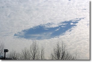
Weather Topic: What are Hole Punch Clouds?
Home - Education - Cloud Types - Hole Punch Clouds
 Next Topic: Mammatus Clouds
A hole punch cloud is an unusual occurrence when a disk-shaped
hole appears in a cirrostratus, cirrocumulus, or altocumulus cloud.
When part of the cloud forms ice crystals, water droplets in the surrounding area
of the cloud evaporate. The effect of this process produces a large elliptical
gap in the cloud. The hole punch cloud formation is rare, but it is not specific
to any geographic area.
Other names which have been used to describe this phenomena include fallstreak hole,
skypunch, and cloud hole.
Next Topic: Mammatus Clouds
Weather Topic: What are Nimbostratus Clouds?
Home - Education - Cloud Types - Nimbostratus Clouds
 Next Topic: Precipitation
A nimbostratus cloud is similar to a stratus cloud in its formless,
smooth appearance. However, a nimbostratus cloud is darker than a stratus cloud,
because it is thicker.
Unlike a stratus cloud, a nimbostratus cloud typically brings with it the threat
of moderate to heavy precipitation. In some cases, the precipitation may evaporate
before reaching the ground, a phenomenon known as virga.
Next Topic: Precipitation
Current conditions powered by WeatherAPI.com


