Weather Alert in Ohio
Flood Warning issued April 2 at 7:50AM EDT until April 5 at 6:00AM EDT by NWS Cleveland OH
AREAS AFFECTED: Holmes, OH; Wayne, OH
DESCRIPTION: ...The Flood Warning is extended for the following rivers in Ohio... Sandusky River At Tiffin affecting Seneca County. Huron River Near Milan affecting Erie County. Black River At Elyria affecting Lorain County. Mahoning River At Leavittsburg affecting Trumbull County. Mahoning River At Youngstown affecting Mahoning and Trumbull Counties. Eagle Creek Above Findlay affecting Hancock County. ...The Flood Warning continues for the following rivers in Ohio... Cuyahoga River At Jaite affecting Cuyahoga and Summit Counties. Blanchard River Near Findlay affecting Hancock County. Maumee River At Waterville affecting Wood and Lucas Counties. Killbuck Creek Near Killbuck affecting Wayne and Holmes Counties. Eagle Creek At Phalanx Station affecting Trumbull County. For the Sandusky River...including Upper Sandusky, Fremont, Tiffin, Bucyrus...Moderate flooding is forecast. For the Huron River...including Milan...Moderate flooding is forecast. For the Black River...including Elyria...Minor flooding is forecast. For the Cuyahoga River...including Hiram Rapids, Jaite, Old Portage, Independence...Minor flooding is forecast. For the Blanchard River...including Findlay...Minor flooding is forecast. For the Maumee River...including Grand Rapids, Waterville...Minor flooding is forecast. For the Killbuck Creek...including Killbuck...Minor flooding is forecast. For the Mahoning River...including Leavittsburg, Warren, Youngstown...Minor flooding is forecast. For the Eagle Creek (Hancock)...including Findlay...Moderate flooding is forecast. For the Eagle Creek (Trumbull)...including Phalanx Station...Minor flooding is forecast. * WHAT...Minor flooding is occurring and minor flooding is forecast. * WHERE...Killbuck Creek near Killbuck. * WHEN...Until Sunday morning. * IMPACTS...At 17.0 feet, Private property on Water Street in the Village of Killbuck flooded. Several county and local roads impassable including State Route 60 south and County Road 621. * ADDITIONAL DETAILS... - At 7:00 AM EDT Thursday the stage was 16.2 feet. - Forecast...The river is expected to rise to a crest of 16.6 feet this afternoon. It will then fall below flood stage early Sunday morning. - Flood stage is 15.0 feet. - Please visit www.weather.gov/safety/flood for flood safety and preparedness information.
INSTRUCTION: Turn around, don't drown when encountering flooded roads. Most flood deaths occur in vehicles. Additional information is available at www.weather.gov/cle. The next statement will be issued this afternoon at 530 PM EDT.
Want more detail? Get the Complete 7 Day and Night Detailed Forecast!
Current U.S. National Radar--Current
The Current National Weather Radar is shown below with a UTC Time (subtract 5 hours from UTC to get Eastern Time).

National Weather Forecast--Current
The Current National Weather Forecast and National Weather Map are shown below.

National Weather Forecast for Tomorrow
Tomorrow National Weather Forecast and Tomorrow National Weather Map are show below.

North America Water Vapor (Moisture)
This map shows recent moisture content over North America. Bright and colored areas show high moisture (ie, clouds); brown indicates very little moisture present; black indicates no moisture.

Weather Topic: What is Graupel?
Home - Education - Precipitation - Graupel
 Next Topic: Hail
Graupel is a form of precipitation that is created by atmospheric conditions
which cause supercooled water droplets to contact snow crystals and freeze to
their surface.
Sometimes known as soft hail or snow pellets, graupel is delicate and easily
destroyed by touch. Whereas hail usually falls during severe weather, graupel
doesn't require such conditions to form, and can form in mild precipitation
similar to situations which produce snowfall.
Next Topic: Hail
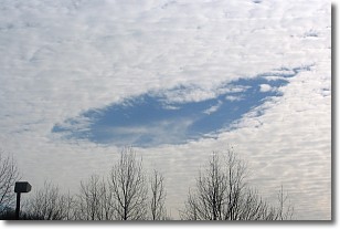
Weather Topic: What are Hole Punch Clouds?
Home - Education - Cloud Types - Hole Punch Clouds
 Next Topic: Mammatus Clouds
A hole punch cloud is an unusual occurrence when a disk-shaped
hole appears in a cirrostratus, cirrocumulus, or altocumulus cloud.
When part of the cloud forms ice crystals, water droplets in the surrounding area
of the cloud evaporate. The effect of this process produces a large elliptical
gap in the cloud. The hole punch cloud formation is rare, but it is not specific
to any geographic area.
Other names which have been used to describe this phenomena include fallstreak hole,
skypunch, and cloud hole.
Next Topic: Mammatus Clouds
Current conditions powered by WeatherAPI.com


